

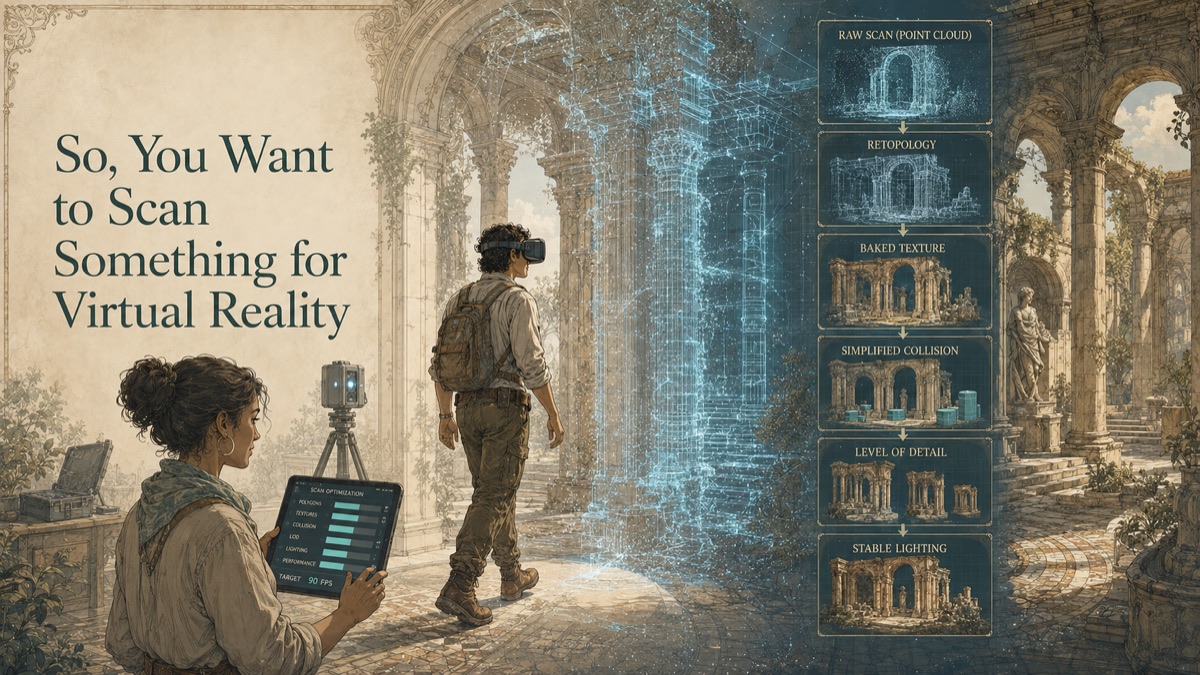
A team wants a realistic VR walkthrough of a facility, gallery, vehicle interior, or training space. The first instinct is to scan everything at maximum detail. Then the headset stutters, floors feel wrong, collision catches on invisible geometry, and a desktop review that looked impressive becomes uncomfortable in stereo. VR does not reward raw data. It rewards controlled, optimized, validated spatial data.
This is why GDS treats scanning as a decision-support workflow, not just a technical field activity. The question is not simply, "Can we scan it?" The more useful question is, "What decision must the data support, and what evidence will make that decision safer?"
Key Takeaway
A scan-ready VR asset must balance measured fidelity with frame rate, scale, navigation, lighting, collision, and headset constraints. Define the headset, engine, interaction, performance budget, and required realism before capture.
The VR Problem: Measured Detail Must Become a Usable Experience
Virtual reality turns geometry into an embodied experience. Users perceive scale, clearance, depth, motion, and surface quality directly. A small error in floor level, collision geometry, normals, or texture projection can be obvious in a headset. Conversely, a highly detailed scan can overwhelm runtime performance if geometry, textures, draw calls, and memory are not managed.
The strongest projects separate what is known, what is measured, what is modeled, and what still requires judgment. That protects the client and the service provider because the deliverable becomes evidence with context, not an implied guarantee beyond the approved scope.
What the Scan or Data Package Should Resolve
The project should separate the measured master from the runtime derivative. The master preserves point clouds, images, scale control, and high-resolution surfaces. The runtime environment may require cleanup, retopology, level-of-detail generation, UVs, baked textures, simplified collision, lighting preparation, and in-engine validation.
A good article page should help the reader choose the right next step. For some projects, that may be a broad spatial baseline. For others, it may be a focused interface scan, a lightweight model, a textured asset, a deviation report, or a consulting engagement before any field capture begins.
The Seven-Phase Scan-to-VR Workflow
Phase 1 - Define experience requirements
Confirm engine, headset, users, navigation, interaction, realism, frame-rate target, and accessibility expectations.
Phase 2 - Set capture boundaries and metric scale
Include reachable, visible, transitional, and reflected spaces so users do not encounter missing context.
Phase 3 - Capture geometry and appearance
Plan scanner positions, imagery, control, lighting, and dynamic-scene management.
Phase 4 - Register and preserve the master
Retain point clouds, images, coordinate information, scale references, and processing notes.
Phase 5 - Build production assets
Clean the mesh, document fills, create UVs, bake textures, build levels of detail, and generate collision surfaces.
Phase 6 - Integrate with the engine
Establish origin, units, materials, lighting, interaction anchors, collision settings, and import transforms.
Phase 7 - Validate in the headset
Test scale, performance, locomotion, collision, comfort, visual quality, and edge cases on the target hardware.
Deliverable Strategy
| Deliverable Type | When It Helps | Key Control |
|---|---|---|
| Registered point cloud | Preserves measured visible conditions as source evidence | Capture date, coordinate basis, coverage, and exclusions |
| Mesh or surface asset | Supports visualization, VR, VFX, reproduction, or measured surface review | Repair status, density, texture, scale, and intended use |
| CAD / STEP / IGES | Supports engineering exchange, reverse modeling, interfaces, and downstream design | Modeled-versus-measured status and design-intent assumptions |
| Drawings / exhibits / reports | Supports stakeholder review, procurement, QA, or decision records | Revision, units, review authority, and limitations |
Table accessibility note: The header row defines each deliverable, its best-use case, and the control required before relying on it.
Use Cases
- Immersive facility and design reviews
- Virtual museum and heritage experiences
- Remote stakeholder walkthroughs and spatial storytelling
- Location-based entertainment, product interiors, and education
Risks and Misconceptions
The point cloud does not always go straight into the headset
Some viewers support point clouds, but production VR usually needs optimized surfaces, textures, collision, and interaction logic.
Maximum detail is not maximum realism
Runtime realism depends on silhouette, materials, textures, lighting, and stable frame rate. Excess polygons may reduce quality.
Mesh repair is not neutral
Hole filling creates non-measured geometry. Repairs may be necessary for immersion, but they should be approved and documented.
Desktop review is not enough
Headset testing reveals scale, stereo, locomotion, collision, latency, and comfort problems that may not appear on a monitor.
Virtual Reality Asset Tradeoff Dial
Move the dial toward measured detail or runtime efficiency. The right balance depends on platform, viewing distance, interaction, and frame-rate targets.
Quick Facts
Continue Reading
The next best article depends on where you are in the project. These suggested reads connect this topic to the next practical decision your team is likely to face.
Frequently Asked Questions
Can GDS deliver a headset-ready VR scene?
GDS can provide measured and optimized assets within an agreed pipeline. Engine logic, software development, and final application packaging should be expressly defined.
What is the difference between a master mesh and a runtime mesh?
The master retains high-fidelity measured surfaces. The runtime mesh is reduced, retopologized, and organized for real-time performance.
Can moving people or objects be removed?
Many artifacts can be cleaned or reconstructed, but those edits should be documented as non-measured geometry.
How is correct scale maintained?
Metric units, scale references, coordinates, and validation checks must be preserved through engine import and transformation settings.
Connect this article to the right GDS workflow
Most physical-to-digital projects touch more than one service. GDS can help determine whether the right starting point is 3D laser scanning, 3D modeling, reverse engineering, or consulting before scope, pricing, schedule, and deliverables are finalized.
GDS supports projects nationwide. Examples from the current locations page include Houston, Dallas, Austin, and Fort Worth.
Ready to Start?
Tell GDS about your asset, your goals, and your deliverable needs. GDS can scope the right scanning, modeling, and reporting for your project.